Coordinate Systems
In: Data_base tree structure->Properties
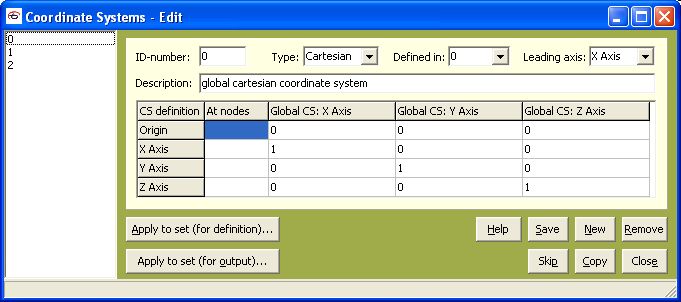
The Coordinate Systems window is of the second type of the general Edit/View window. It can be run by a click on the View or Edit command in the right-hand click popup menu of the data_base tree structure. Its typical look in the edit mode is in the following figure:
If the window is ran in view mode, the listboxes Defined in and Leading axis are not visible, because they are used only for a definition of new coordinate systems. As regards the edition or creation of new c.s., even if some coordinate system was defined in another coordinate system than the global c.s., the coordinates are recalculated to global coordinate system, when it is saved. This procedure is done in order to ensure that there are no hidden dependencies that could be disregarded.
When the task is created, a global cartesian system with ID-number = 0 is defined. This means that this global system exists from the start. The other systems can be imported (e.g. from *.nas/*.dat files) or defined within PragTic.
It can happen that the relation of some coordinate system to particular elements, nodes or isolated points has to be changed. The user can use the Apply to set (for definition) button, which triggers a new dialogue, where the user can select the nodal set , to which he wants to apply it. The coordinate system is related to the definition of coordinates of the nodes. This button is enabled only in the Edit mode.
The same can be done by the other button (Apply to set (for output)), but here it can influence also elements or isolated points. The related coordinate system defines the system at which the results are printed.
Definition of a new C.S.
Any coordinate system can be defined by three points in a space. There are two options - the first one is that the points are related to specified nodes or isolated points. Because there can be nodes and isolated points with the same ID, the nodes are searched for primarily. If you want to set isolated points instead, switch to it by a right-hand click on the mouse somewhere in the table and an appropriate selection in the opened menu.
The second option is a direct definition of the point coordinates. PragTic enables input of coordinates also in other c.s. than the global cartesian one is (selected in Defined in listbox).
The most important point is the origin, which has to be definitely set. The second and third point form together with the origin one of the plane (i.e. all three points should not lie in one line), which is sufficient to describe normal. To describe the c.s. uniquely, one of the points has to lie on the future axis of the c.s. - the selection in the listbox Leading axis marks, which one it has to be.
Definition of all four lines would cause that the c.s. derivation would work with redundant number of inputs. Thus it is checked that items only in three lines (one of which is the origin) are set.
During the definition, the algorithm searches first for node/isolated points IDs, because these are primary target. Only when they are not found, it looks also at the rest of the line.
It was already mentioned before, that a transformation of the new c.s. to the global coordinate system is done automatically during its derivation.
Note: From PragTic v.0.2 betaH upwards, the nodes description, isolated points and result files can be viewed in selected coordinate system.
More:
© PragTic, 2007
This help file has been generated by the freeware version of HelpNDoc